Alberta Southwest
Find locally-rooted places and experiences to enrich your visit and support the communities
GoGood in Alberta Southwest
Choose authentic local places committed to stewardship and sustainability. Sign up to save places, plan trips, and promote your business on GoGood.
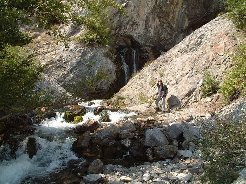
Basin Cave Pictographs
This site invites reflection upon the thousands of years of First Nations society in the Rocky Mountains, and the subsequent imprint of just a few decades of non-native occupation. Inside this astounding little cave, are a number of ochre-pigmented pictographs depicting local wildlife. The pictographs were carefully positioned around the cave's spring basin so still and clear that you cannot discern the water's surface. Sadly, these priceless and irreplaceable artworks have been desecrated by layers of graffiti, left by recent visitors to mark their casual passage. Best Places to Go Basin Cave is clearly visible from Provincial Highway 3 on the opposite shore. It is not, however, so easy to get to. You really need a boat. Visitors with paddle or power boats can launch at the Crowsnest Lake parking lot, or from the eastern shoreline, and motor across the lake to the cave. A broad cobble fan marks the entry of the Cave's short stream into Crowsnest Lake, and provides decent beaching for watercraft. Walking is not recommended because of the danger posed by the many daily trains using the rail line along the lake's north shore. Outlaw hikers do start from the abandoned power house at the lake's eastern extremity, or from the parking area at the western end of the lake. While it is unlawful and ill-advised to walk the CPR railway line, there is usually room to step well away from the tracks in the very likely event that a train will pass during the hike. Prudent scofflaws ensure that no trains are coming before walking the tighter sections of rail line. Best Times to Go Windless summer days are best for boating on Crowsnest Lake. In spring, the gush of water from Basin Cave creates a substantial waterfall, easily visible from the opposite shore. What You Should Know Before You Go It is dangerous and unlawful to walk along railway tracks in Canada. Driving Directions from Nearest Town or Landmark Park at the abandoned power house at the eastern extremity of Crowsnest Lake. Alternatively, boaters can start from the parking lot at Crowsnest Lake. Scofflaw hikers sometimes start from the Island Lake Recreation Area at the western end of the lake.

Coleman National Historic Site
The community of Coleman is situated in the municipality of Crowsnest Pass, atop what was once one of the most productive coalfields in Western Canada. The town, with its mine site, commercial area and streets lined with miner’s cottages, preserves the atmosphere of an early mining town. Driving Directions from Nearest Town or Landmark From Coleman's highway commercial strip along Alberta Highway 3, turn south to the old town centre of Coleman. The Crowsnest Museum is located in a former school at the intersection of 77th St. and 18th Ave. Downtown Coleman seems always to be just on the cusp of conversion from neglect to gentrification. It remains, in many respects, frozen in the 1950s when Canadian railroads still relied on steam locomotion and there was a ready market for Crowsnest coal. Crowsnest Pass is the last mountain community in Alberta where properties are priced within reach of the average Calgarian wanting a piece of the Rockies, if only on weekends. The probable consequence will be the eventual rescue of downtown Coleman's unoccupied storefronts and their re-dedication to the non-essential goods and services desired by Albertans escaping their weekday world of cubicle and condominium. Historical Time Period for Site Late 19th, early 20th century.
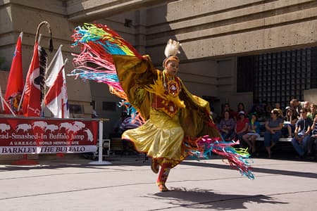
Head-Smashed-In Buffalo Jump, World Heritage Site
Before the horse and the gun, native peoples hunted bison by stampeding the animals over rock ledges. One particular precipice just west of today's Fort Macleod was a prime slaughtering ground for plains dwellers. A bed of bones 10 metres attests to 5,700 years of continuous use. It was at the end of such traditional bison hunting that the site earned its contemporary name. About 1850, a young brave too close to the hunt was crushed by the mass of falling animals. If you can, time your visit for one of the summer days when local Blackfoot drummers and dancers perform on the outdoor plaza. The season starts with National Indigenous Day, June 21, followed by early afternoon performances each Wednesday in July and August. Though based on long-established social rites, contemporary native dancing is a living art practiced competitively at pow wows throughout North America. Innovation in footwork and dress is esteemed as much as allegiance to tradition. Dances and fashion design are freely exchanged among tribes to invigorate this ancient art form with vibrant creativity. Historical Time Period for Site Pre-history to mid-1800s Driving Directions from Nearest Town or Landmark Head-Smashed-In Buffalo Jump is located 18 kilometres (15 minutes) north and west of Fort Macleod on secondary Highway #785 (paved).
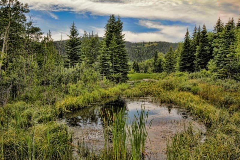
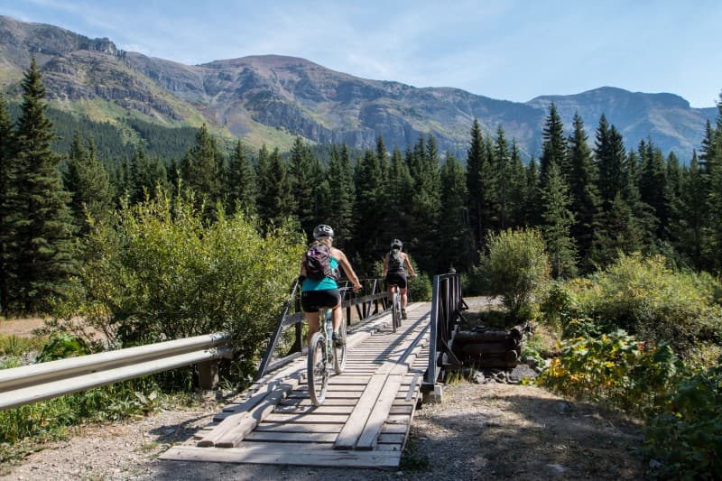
Beauvais Lake Provincial Park
Rare plants such as the white bog orchid, mountain ladyslipper and blue camas can be observed in spring and early-sumer bloom. Nestled in the foothills of southwest Alberta, almost 3,000 acres, this provincial park protects a unique landscape of fescue grassland, wetlands, and forests of aspen, poplar, Douglas fir, spruce and pine. Beauvais Lake is home to loons, osprey, eagles, geese, mule deer, moose, elk, black and grizzly bears to name a few species of wildlife that inhabit the montane landscape. As early as 1881, newcomers settled near Beauvais Lake; trails lead to these early homestead sites and to beaver ponds, wooded slopes and lakeside walks. Spectacular views of Alberta's Livingston Range, The Castle Wilderness, Porcupine Hills and British Columbia's Flathead Mountain Range meet your gaze as you climb Piney Point or Mount Albert in the park. Wildflower and bird watching are at their peak in June and July, bring your wildflower and bird guides. Visitors appreciate great half day hikes or walks, along the trail system and the quiet camping opportunities. As well, Beauvais Lake is only 20 minutes from Pincher Creek and a short drive to museums, annual community events and other hiking trails. The park has a nice secluded winter camping spot in the campground, bring your own water, several sites are ploughed. Highlights of this State or Provincial Park Summer and Winter Adventures: Great camping - small and secluded camping power and basic service, you can prebook with reserve.albertaparks.ca or choose from our first come first serve sites. Walk in tent area also available. Great for RV's, small campers, tenting. Quiet, comfortable, well maintained campground and facilities. Great Group Camping - for family reunions, gatherings, scout and youth group camping reserve the Homestead Group Camp. Beautiful camp kitchen shelter, solar lights, clean outhouses, lots of space for camping with tents and trailers and RV's. Enjoy the following activities in the summer: bird watching, wildlife viewing, hiking, walking, cycling, amphibian monitoring, summer lectures, superb, well maintained trails, over 30 km of hiking trails, fishing, boating, camping, camp fires, interpretive programs, education programs. Enjoy the following activities in the winter: bird watching, birding, wildlife viewing, snowshoeing, nordic skiing, skiing, ice fishing, camping (select sites open all year), skating. Check nordic ski trail reports via the SW Park Update sent to local visitor centres and available on www.albertaparks.ca search for Beauvais Lake. Key Access Points to this State or Provincial Park The only access is on secondary road 775 to the main entrance of the park. Piney Point and the homestead hiking trail heads are accessible from the Beaver Creek Day Use Area (parking is available, outhouses and kitchen shelters are located in this day use area). The rest of the trails can be accessed from the playground in the campground (parking is available). Driving Directions to Key Access Points Beauvais Lake is 20 minutes drive from the town of Pincher Creek, 2 hours from Calgary and just over an hour from Lethbridge and just under an hour from Waterton Lakes National Park. Follow highway 507 west from the town of Pincher Creek approximately 12 km. At (paved) secondary road 775 turn south (watch for the sign). Follow 775 for approximately 8 km. This road heads straight into Beauvais Lake Provincial Park. At the entrance make a turn at the first small gravel driveway on the right to find the seasonally operated park office. The second right turn leads to the Campground (follow the sign and turn right again) or the Beaver Creek Day Use Area (follow the sign straight). Hiking trail heads can be found at the Beaver Creek Day Use Area or the playground in the Campground. If you stay on the paved road, you will find the boat launch at the head of the lake and further along the road, just passed the cottages, the north shore day-use area with two camp kitchens, outhouses and a playground.
Belly River
The Belly River flows north from U.S. Glacier National Park into Canada's Waterton Lakes National Park and then northeast out of the park towards the Oldman River in Alberta. Boat Access Locations For 30 km of Grade II river, put-in at the bridge where Provincial Highway 6 crosses the river. Take-out at Secondary Highway 800 bridge. Belly River Campground users can put in at the campground itself. KNOW BEFORE YOU GO- Prevent Spread of Aquatic Invasive Species Alberta Waterton Lakes National Park Watercraft Regulations: Reglement Regulations Alberta Environment & Parks: Alberta.Ca Piegan/Caraway (US Hwy 89 / AB Hwy 2) Watercraft Inspection Station \ Decontamination Unit @ St. Mary Reservoir 7 days a week Blackfeet Nation Motorized use permitted only on Duck, lower St. Mary’s, Mission and Four Horn Lakes. Felt soled waders, ballast boats, seaplanes and float planes prohibited. All boats – motorized and non-motorized boats must be inspected prior to launch. Mandatory Inspection Stations: Browning: 6:30 AM to 9:30 PM 7 days per week Seville: 7:00 AM – 5:00 PM 7 days per week \Tentatively closing after Labor Day Weekend Birch Creek: 7:00 AM – 5:00 PM 7 days per week \*Tentatively closing after Labor Day Weekend Fishing Access Highlights Start right inside the Belly River Campground and work up or downstream. Fishing Highlights The most accessible trout angling is within Waterton Lakes National Park. The Belly River Campground is an excellent base for angling the river, within and without the park. The North Fork Belly River and its tributaries are closed to fishing. A national park fishing permit is required for fishing in the national park, and is available at the information centre and other outlets in the community of Waterton. For more information, visit Reglement Regulations Paddling Highlights The portion of the Belly River inside Waterton Lakes National Park provides the best starting point for paddling adventures. The Belly River Campground provides an excellent point of departure.
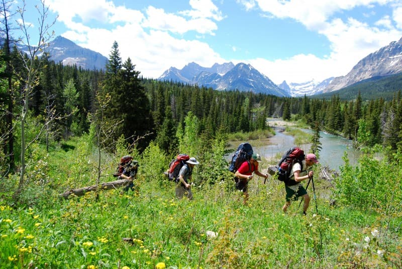
Castle Provincial Park & Castle Wildland Provincial Park
Castle Provincial Park and Castle Wildland Provincial Parks offer front-country, back-country and wilderness experiences across 105,500 hectares. Alberta's Castle Parks protect diverse habitat and major wildlife movement corridors for wide-ranging species such as grizzly bears and westslope cutthroat trout. As of February 2017, the Government of Alberta officially established the Castle Provincial Park, and the expansion of the Castle Wildland Provincial Park. The establishment of these areas under Parks’ legislation protects important fish and wildlife habitats, shared international wildlife populations and provides headwater protection. In addition, significant recreation and tourism potential of the area will be enhanced, contribute to the local economy, improve the quality of life of Albertans and continue to position Alberta as an international tourism destination. Conservation of nature will be the primary objective of both parks. Biodiversity conservation, protection of headwaters and species at risk, and ecological connectivity will underscore management decisions. Indigenous Peoples’ rights, cultural values and traditional uses are of critical importance. Driving Directions to Key Access Points Pincher Creek to Castle Provincial Park: West of Pincher Creek on Hwy 507, southwest on Hwy 774 or follow Hwy 3 west of Pincher Creek to Hwy 507 then to Hwy 774 Crowsnest Pass to Castle Wildland Provincial Park- Carbondale River: From Main Street in the Crowsnest Pass community of Blairmore, follow 133 Avenue across the railway tracks (GPS N49 36.438 W114 26.000) and continue to 131 Street. Turn west and follow the sharpish uphill bend to the end of asphalt and the start of Sartoris Road (GPS N49 36.225 W114 26.237). From here on, the road is surfaced with gravel, not always well-graded. Continue south along Sartoris Road to its end at a T-intersection with Township Road 61A (GPS N49 27.252 W114 24.559). From there, you may follow the gravelled road east to its junction with Highway 507 (GPS N49 30.583 W114 12.115). Highlights of this State or Provincial Park The Castle Provincial Park is approximately 25,500 hectares in size, and includes the previous Lynx Creek Provincial Recreation Area (PRA), Castle Falls PRA, Castle River Bridge PRA, Syncline PRA and Beaver Mines PRA. The Provincial Park offers a wide range opportunities to reconnect with nature through leisure, learning and recreation. Facilities and infrastructure support a front-country experience. The Castle Wildland Provincial Park is approximately 80,000 hectares in size, and includes the most critical and sensitive areas for headwaters and wildlife, including major wildlife movement corridors for wide-ranging species such as grizzly bear, and habitat for threatened species such as westslope cutthroat trout. The Wildland Provincial Park provides for back-country and wilderness experiences where facilities will be limited to trails and back-country campsites that minimize visitor impacts. There will be limited built infrastructure. Winter Guided Programs Starshoeing is scheduled every Friday evening from December 28, 2018 until March 29, 2019, and the free 2nd Annual Castle Christmas Bird Count Guided Hikes are on Saturday December 29th, 2018. Dig out your winter gear and enjoy the outdoors!
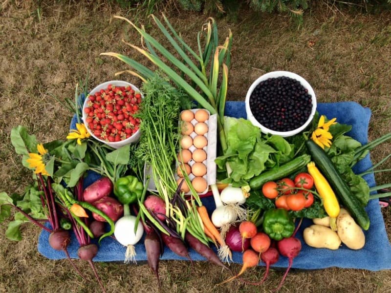
Pincher Creek Farmers' Market
Locally grown and made items that include: Fresh local produce, locally raised pork, beef and poultry, homemade baking, handmade sewing items, knitted items, quilts, local honey, handmade jewelry, local crafts, women's clothing, and homemade soaps. A dinner concession is available. You can enter to win a basket of goodies from the Artisans every Friday. Free coffee is available compliments of the Artisans. Email pincherpioneermarket@gmail.com or call 403-627-0830 and online at Pioneercountrymarket for more information or to book a table. Driving Directions Located on Main Street in front of the Recreation Centre 895 Main Street, Pincher Creek, Alberta
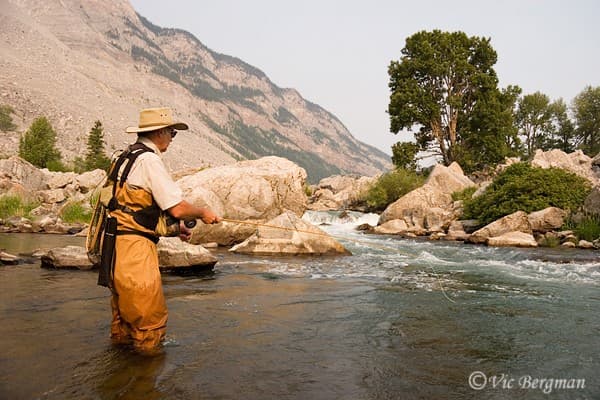
Crowsnest River Flyfishing
Shallow riffles, deep pools, and runs too rocky for drift boats make the Crowsnest River above Lundbreck Falls a treasured preserve for traditional dry fly anglers who prefer to walk and wade, sometimes casting with rods hand-crafted from Chinese bamboo and silk lines braided in France. Accessibility Notes The Crowsnest River parallels southwest Alberta's Highway 3 (Crowsnest Highway) along its entire length, from its source in Crowsnest Lake to its confluence with the Oldman River at the Oldman River Dam. Highway 3 crosses the Crowsnest River near Crowsnest Lake, at Blairmore, at Frank and below Lundbreck Falls. Although private property does prohibit access in some locations, there is ample public access to the river's long stretches of fishable water. Best Access and Parking Areas The Crowsnest River is regarded by avid fly fishers as one of western Canada's premier trout streams. The river is born in the cold waters of Crowsnest Lake, which is located amid the peaks of the continental divide only two kilometres east of the Alberta-British Columbia border. The river flows eastward through the Crowsnest Valley and Municipality of Crowsnest Pass, passing through the communities of Coleman, Blairmore, Frank and Bellevue, before leaving the mountains and foothills to join the Oldman River at the Oldman River Dam. The river's feisty rainbow trout are the main attraction to anglers, although cutthroat and bull trout are also present. The pools and riffles of the Crowsnest are a haven for both novice and expert fly fishers. Although fish can be taken from the entire length of the Crowsnest River, the stretch of river downstream from the bridge on the Hillcrest East Access to the crossing of Highway 3 (Crowsnest Highway) below Lundbreck Falls is the most popular run. Hints and Tips for Fishing this Area In general, the fishing season opens mid-June, which coincides with the end of the spring runoff. The river usually clears quickly and remains crystal clear through the summer and fall. Special catch-and-release and slot size regulations are in effect in different stretches of the river, and anglers must be aware of the regulations. Fishing is great throughout the season and success is more directly affected by day-to-day weather and insect hatches than major seasonal changes. Rules and Regulations for Fishing Area An Alberta fishing license is required to fish the river. Anyone planning to fish the Crowsnest River must check provincial regulations, as they often change from year to year.
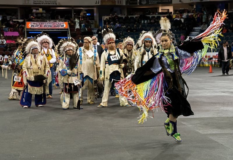
International Peace Pow Wow
Tentative Schedule Grand Entries: Saturday: 1:00 pm & 7:00 pm Sunday: noon Event Setting The Enmax Centre is an all-purpose arena that seats 6,500 in reserve seating and 7,100 in festival seating. The Enmax Centre is located at 2510 Scenic Drive South Lethbridge, Alberta.
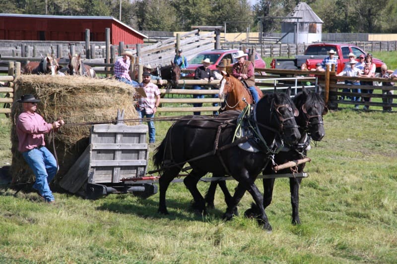
Harvest & Heavy Horse Weekend / Récolte et fin de semaine de chevaux lourds
Ages Festival is Appropriate For All ages The horse-power harvest commences in the Bar U Ranch field. Watch teamsters of today guide their heavy-horse teams around a course. See how skills of days gone by are demonstrated by drivers from 18 to 80 years of age! Keeping horsepower history alive for all to enjoy and be inspired by! La moisson à l’aide de chevaux débute dans le champ du Bar U. Dimanche, venez voir les équipes d’aujourd’hui guider leurs chevaux lourds dans un parcours les mettant à l’épreuve. Des conducteurs âgés de 18 à 80 ans feront la démonstration de leur savoir-faire d’antan. Une vraie source d’inspiration et de divertissement. Driving Directions Bar U Ranch National Historic Site is located approximately 95 km (59 miles) south of Calgary on Highway 22, 13 km (8 miles) south of Longview. From Calgary, go south on Highway 2, then west on Highway 540, cross over Highway 22 (also known as The Cowboy Trail) and continue going west for approximately half a kilometer. Event Setting The site has many historic buildings and structures, illustrating various stages of ranching development, and is rich in cultural landscape features. A visitor orientation centre and a vibrant living history program interpret a time when the West was young.
Built for Everyone in Responsible Travel
Whether you're planning your next adventure, running a local business, or stewarding a destination, GoGood provides the tools and insights you need.
For Travelers
Find authentic, locally-rooted experiences that connect you with culture, nature, and communities. Every choice you make creates positive impact.
For Businesses
Get listed on GoGood, measure your stewardship performance, and reach travelers who value local ownership and authenticity.
For Destination Stewards
DMOs, nonprofits, and community leaders: grow regenerative tourism that benefits your place and people while reducing negative impacts.
Tourism That Creates Positive Impact
Verified Stewardship
Every destination and business is assessed through the Stewardship Scan — built on Green Destinations' Good Travel Scan and extended with our Bonus questions on local ownership and certification.
Community-Centered
We prioritize local ownership, cultural preservation, and community well-being in everything we do.
Regenerative Tourism
Go beyond "doing less harm" to actually improving the places you visit through conscious travel choices.